MobilePlat™

The revolutionary plat map.


Plat maps are now mobile.
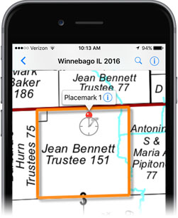
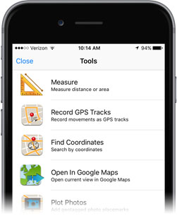
MobilePlat is a seamless, geo-referenced plat map (.pdf) that is designed for use on iPad and iPhone with Avenza's free PDF Maps app for personal, non-commercial use. 

So many great features all in one place.
View your location using GPS, search Google for locations, plot placemarks, add notes and attributes–all from your mobile iOS device. (Learn more)

Save money and stop streaming data.
All maps are stored on your device and can be used offline without using WiFi or data so you save money and stop spending your time loading maps.

Open PDF Digitial Products Comparison


Technical Specifications

File Format: .pdf
Common Supporting Software:
Avenza® PDF Maps app
(iPad and iPhone) - Android version coming late 2013.
Size:
60-175 MB per county
Color:
Availability varies by county & edition.
Georeferenced:
Yes
Projection:
State Plane NAD 83
Multi-layered:
No
Attributed:
No
Includes PINS:
No
Includes Aerials:
No
Includes License:
Yes. Included in price,
no annual renewal fee.

MobilePlat on iPad and iPhone

Download Avenza® PDF Maps

Are you a commerical user? Learn about Avenza's PDF Maps commercial licensing program.

PDF Maps is free for personal, non-commercial use. A low-cost PDF Maps commercial licensing program is available, designed to meet the needs of any commercial enterprise, educational institution or government agency. Contact Avenza for more information on commercial licensing.

Recommended Industries

  • Appraisal
  • Real Estate
  • Surveyor

View additional sample images

Check Availability
Choose a State
  • Please select a state
  • Alabama
  • Alaska
  • Arizona
  • Arkansas
  • California
  • Colorado
  • Connecticut
  • Delaware
  • District Of Columbia
  • Florida
  • Georgia
  • Hawaii
  • Idaho
  • Illinois
  • Indiana
  • Iowa
  • Kansas
  • Kentucky
  • Louisiana
  • Maine
  • Maryland
  • Massachusetts
  • Michigan
  • Minnesota
  • Mississippi
  • Missouri
  • Montana
  • Nebraska
  • Nevada
  • New Hampshire
  • New Jersey
  • New Mexico
  • New York
  • North Carolina
  • North Dakota
  • Ohio
  • Oklahoma
  • Oregon
  • Pennsylvania
  • Rhode Island
  • South Carolina
  • South Dakota
  • Tennessee
  • Texas
  • Utah
  • Vermont
  • Virginia
  • Washington
  • West Virginia
  • Wisconsin
  • Wyoming
Choose a County
  • Choose a county
Find Maps Now

See State Name County Map